Overnight Four-Hour Full Closures Scheduled on I-64 West in Hampton for Overhead Sign Installations
As early as Sept. 3, contractor crews with the Virginia Department of Transportation (VDOT) are scheduled to implement overnight full directional closures lasting up to four hours each on I-64 west in Hampton to support overhead sign installations as part of the Hampton Roads Express Lanes (HREL) Hampton Segment project.
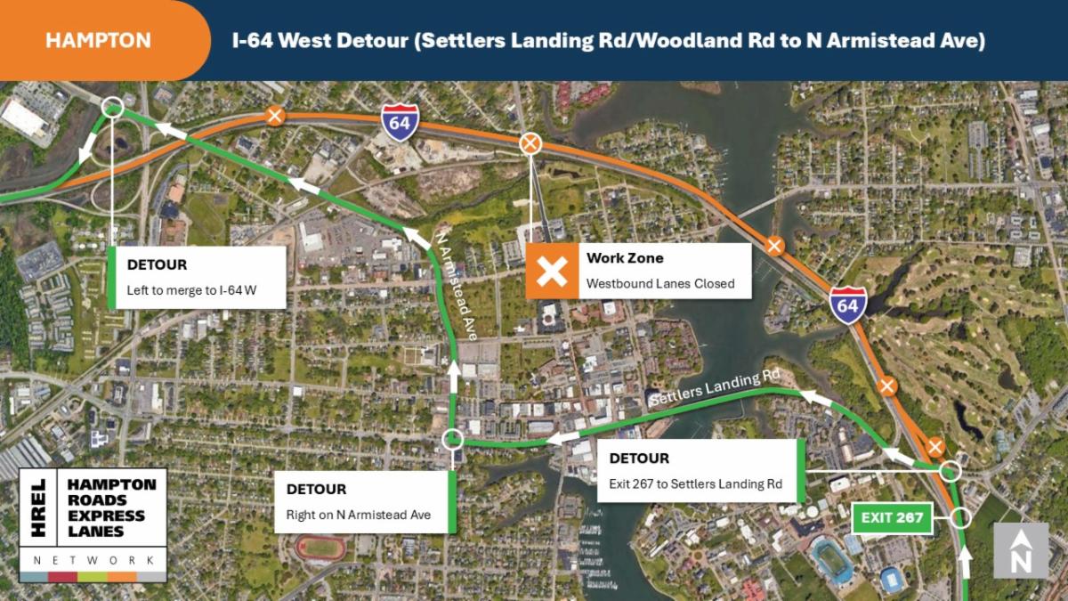
The full four-hour closures will occur on I-64 west from Settlers Landing Road/Woodland Road (exit 267) to North Armistead Avenue (exit 265), with signed detours in place. All work is weather- and schedule-dependent; therefore, this schedule is subject to change.
I-64 West Closures: As Early as Sept. 3 and Sept. 4 (Backup Date: Sept. 5)
- I-64 West Full Closures: All lanes on I-64 west will be closed overnight starting as early as Wednesday, Sept. 3 and Thursday, Sept. 4, from 12:01 a.m. to 4 a.m., between Settlers Landing Road/Woodland Road (exit 267) and North Armistead Avenue (exit 265). Signed detours will be in place, directing motorists from I-64 west to Woodland Road/Settlers Landing Road (exit 267) and North Armistead Avenue to access the on-ramp to I-64 west.
- I-64 West On-Ramp from Settlers Landing Road/Woodland Road Closure: During these interstate closures, the on-ramp from Settlers Landing Road/Woodland Road to I-64 west will also be closed. Motorists traveling east on Settlers Landing Road will be directed to Woodland Road, East Mercury Boulevard, Old Buckroe Road, back to Woodland Road, Settlers Landing Road, and North Armistead Avenue to access the on-ramp to I-64 west.
- Other Traffic Impacts: Starting as early as 10 p.m. on Tuesday, Sept. 2 and Wednesday, Sept. 3, the contractor will begin implementing single-lane closures on I-64 leading up to the full westbound closures at midnight.
Closures and detours will continue periodically this summer and fall to accommodate additional overhead sign installations. Public notifications will be provided in advance of any additional scheduled full closures.
Motorists are encouraged to use I-664 as an alternate route to avoid the work area when possible and are reminded to use caution when traveling near work zones, obey posted speed limits, follow lane markings and barrier guides, be alert to digital message signs and drive distraction-free.
Before hitting the road, consider using VDOT’s free 511 Virginia traffic tools, or the free 511-integrated Waze GPS app, to check for the most up-to-date road and travel conditions. VDOT’s 511Virginia website and mobile app offer information about construction, traffic, incidents, and congestion, as well as access to traffic cameras, weather-related impacts and more.
Hampton Roads Express Lanes Hampton Segment (Phase 4C) Project
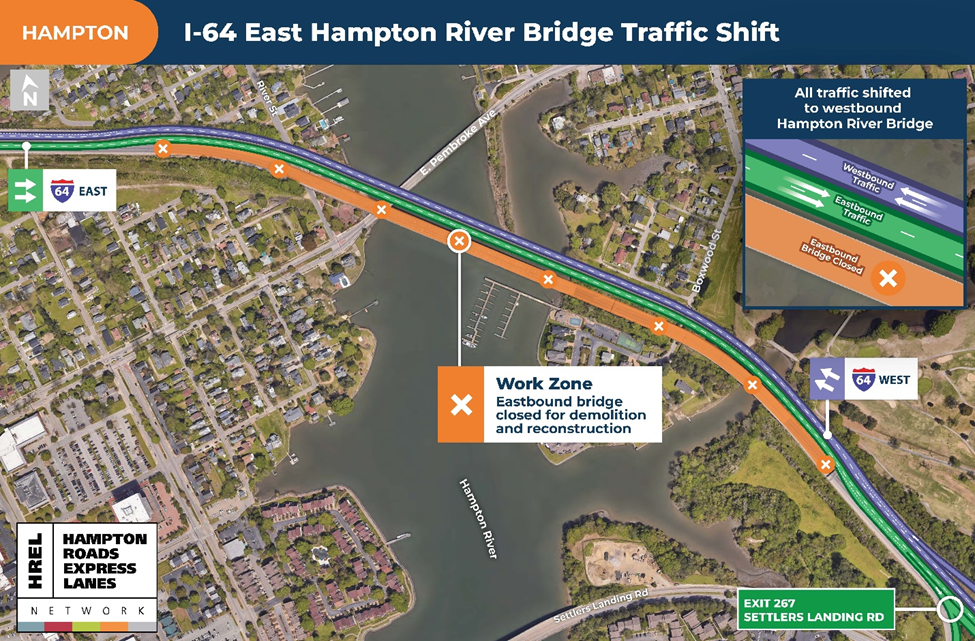
This work is part of the HREL Hampton Segment that includes converting the three existing east- and westbound general purpose lanes on I-64 into one Express Lane, one part-time Express Lane, and two general purpose lanes in each direction. The project will widen I-64, repave the existing lanes, and add an additional 12-foot-wide travel lane in each direction from west of Mallory Street (exit 268) to LaSalle Avenue (exit 265A) for a total of 2 miles. This section of the interstate includes work on six mainline bridges and one pedestrian underpass. The two eastbound bridges over the Hampton River will be replaced, and the westbound Hampton River bridge will be widened and rehabilitated.
The HREL Hampton Segment will ultimately become a part of an overall continuous 45-mile high-occupancy toll Express Lanes network on I-64, from west of Denbigh Boulevard in Newport News to the I-264/I-664 Bowers Hill interchange in Chesapeake. As traffic demand continues to increase in the region, incorporating the Express Lanes dynamic tolling model, together with other interstate improvements, provides an additional approach to managing congestion in the long term and providing more travel choices and a reliable travel network for Hampton Roads motorists.
To view an interactive map displaying long-term traffic impacts across the various HREL construction projects, visit https://www.vdot.virginia.gov/projects/major-projects/64expresslanes/long-term-traffic-impacts/. For more information on the Hampton Roads Express Lanes projects and to learn more about construction updates, traffic impacts and to sign-up to receive project updates, visit 64expresslanes.org.